

Virginia Map Modernization Management Support
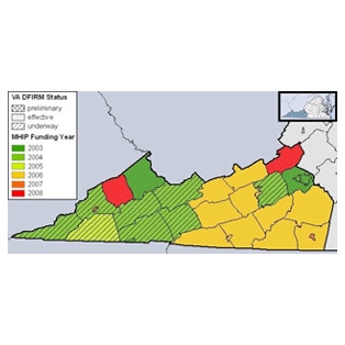
The Center for Geospatial Information Technology (CGIT) conducted activities for the Map Modernization Management Support (MMMS) across the Commonwealth of Virginia, commissioned and funded by the Federal Emergency Management Agency (FEMA) and the Virginia Department of Conservation and Recreation (DCR). Part of a nationwide effort which included 20,000 communities, this long term project sought to evaluate the status of the Commonwealth of Virginia floodplain map modernization initiative.
In cooperation with DCR, CGIT established partnerships with local community officials and used the relationships to identify and prioritize the local mapping needs. The information was then employed to obtain available flood mapping data from the communities or other local organizations. CGIT provided technical assistance in centralizing and organizing the communities’ input regarding the mapping needs.
See our Previous Projects
