

Central Virginia Planning District Commission Hazard Mitigation Plan 2020 Update

A Hazard Mitigation Plan (HMP) identifies specific measures to be taken by a community to reduce their vulnerability from future hazard events and shorten the recovery time. Contracted by the Central Virginia Planning District Commission (CVPDC, aka, Region 2000), the Center for Geospatial Information Technology (CGIT) at Virginia Tech has carried out the original plan (2006), the first update (2013), and the most recent update (2020) of CVPDC HMP.
This CVPDC HMP 2020 Update was developed to meet the Disaster Mitigation Act of 2000 (DMA2K) which requires state and local governments to identify, assess risk and vulnerability, and describe actions to mitigate impacts of natural hazards. The CVPDC HMP 2020 has been developed to serve the people within the CVPDC area by providing the impetus for making our homes, businesses, and communities as safe as possible against the impacts of natural, technological, and man-made hazards. This HMP contains the latest geographic and demographic information, along with a thorough assessment of the potential hazards faced. This plan addresses the overall capability of local governments, businesses, organizations, and property owners to reduce or eliminate the vulnerability to these hazards. Moreover, the plan outlines coordinated mitigation strategies, including long-term goals, objectives, and a wide variety of mitigation actions.

Highlights of the HMP 2020 Update:
Updated demographic information.
Updated inventory of critical facilities and infrastructure. The inventory of critical facilities and infrastructure was updated by combining several data sources, including local data submitted by jurisdictions, ESRI data, Hazus inventory data, and Homeland Infrastructure Foundation-Level Data (HIFLD). More than 600 facilities were identified.
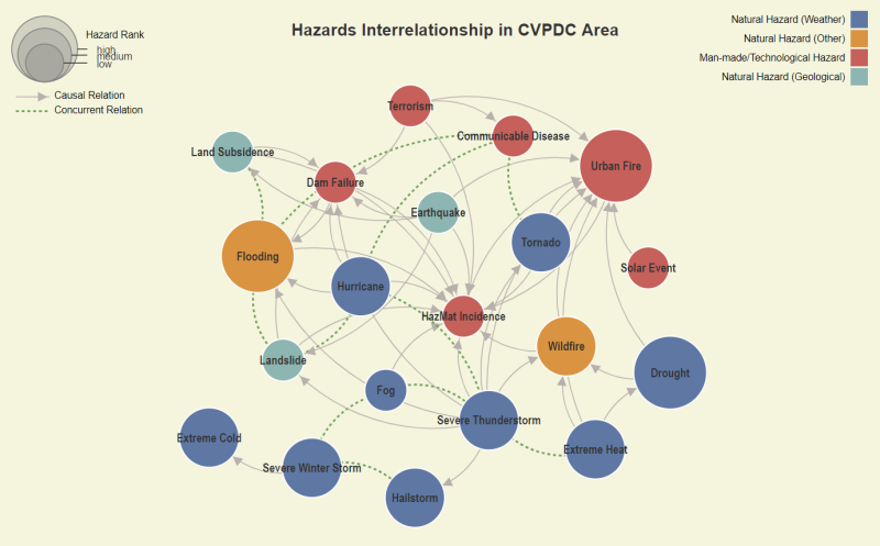
Additional natural, technological, and man-made hazards. A total of 15 natural hazards and 5 man-made/technological hazards were assessed.
Updated hazard history. The historical occurrence of hazards was updated with information from FEMA Disaster Declarations Summary, National Center for Environmental Information (NCEI) Storm Events Database, Virginia Department of Conservation and Recreation, Virginia Department of Forestry, and other authoritative sources.
High hazard potential dams. A new Dam Failure chapter added details about the impacts of high hazard dam failure for all high hazard dams listed in the Virginia Dam Safety Inventory System, including general site information, mapped dam failure inundation zones, and vulnerable structures in the region.
Enhanced level of analysis for Hazard Identification and Risk Assessment (HIRA). The latest version of HAZUS software equipped with 2010 Census data was used for loss estimates in HIRA. HAZUS Level 2 analysis was applied for flooding and dam failure hazards to produce a more accurate prediction of damages and losses. The Level 2 analysis improves the results of Level 1 by supplementing default data with user-supplied data such as up-to-date building inventories and flood elevation data. The HIRA involved integrating local, site specific data for all structures in the floodplain and dam failure inundation areas to create a more comprehensive risk assessment.
Cascading hazards and multi-hazard interrelationships. The plan explored various concurrent and causal interrelations between hazards in the CVPDC area, and developed weighted network diagrams to depict relationships between hazards and their impacts on people, built environment, and infrastructure. This multi-hazard network model is available as an interactive graph in the CVPDC HMP 2020 Update website.
This project was funded by the Federal Emergency Management Agency (FEMA) through the Virginia Department of Emergency Management.
See our Previous Projects
