

Geographic Engineering Tools for Wireless: Evaluation of Broadband Systems
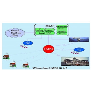
In conjunction with the Center for Wireless Telecommunications at Virginia Tech, students and faculty developed a suite of software tools (referred to as the GETWEBS, Geographic-Engineering Tool for Wireless: Evaluation of Broadband Systems) for wireless network system design and layout. This research brought together students from electrical engineering, business, and the social sciences to evaluate implementation strategies for 4G wireless communications using the Local Multipoint Distribution Services (LMDS).
GETWEBS consisted of two summer courses (2000-2001) taught by three full professors, including Dr. Bill Carstensen from Geography and CGIT. Students learned basics of radio engineering, GIS, and financial assessment of ventures; as a final project, they developed design and layout plans for counties in southwestern Virginia.
See our Previous Projects
