

Local All Hazards Mitigation Plans
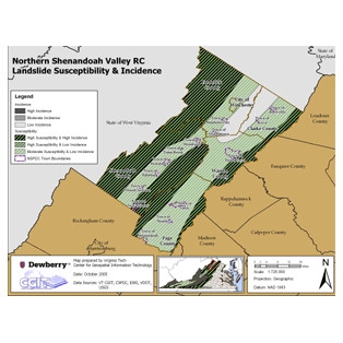
The Center for Geospatial Information Technology (CGIT) and Dewberry & Davis, LLC worked with Virginia regional planning agencies to complete multi-jurisdictional, all-hazard mitigation plans. The CGIT/Dewberry & Davis, LLC partnership included the analysis and evaluation of four Virginia regions: West Piedmont, Northern Shenandoah, Northern Neck, and Crater.
In addition, CGIT worked with Region 2000 (Lynchburg and the surrounding area) Regional Commission on the development of their Hazard Mitigation plan, and assumed the lead role in all aspects of this plan, including plan coordination, meetings, hazards identification and risk assessment, mitigation strategies, and plan adoptions. CGIT also assisted the Central Shenandoah Planning District Commission by developing the Hazard Identification and Risk Assessment portions of the mitigation plan.
See our Previous Projects
