

VDEM HAZUS Hurricane Project
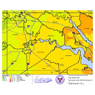
This project was developed for the Virginia Department of Emergency Management (VDEM) to generate hurricane wind hazard assessment maps for their Virginia Map Atlas. The map series will provide demographics, impact information, and damage estimates by census tract for 10, 50, and 100 year hurricane winds as projected by FEMA HAZUS-MH software. VDEM will utilize these maps during future hurricane events to project potential impacts and where they will need to focus their mitigation efforts.
HAZUS simulations were performed for each county and city and output statistics and loss estimates were exported into a GIS format to develop statewide data layers and maps. The state is tiled into 24 sections at a 1:400,000 scale so that the census tracts across the entire state can be viewed and interpreted in an effective manner. Final maps are in a PDF format and are accessed using a clickable state PDF basemap.
See our Previous Projects
