

CGIT Data Helps to Make Virginia Roadways Safer
On Thursdays, Fridays, and Saturdays from 9 p.m. to 2 a.m., off-duty police officers are hired to make rounds on Virginia Tech’s campus in Blacksburg. They have a specific purpose — to spot and arrest people who are driving under the influence of alcohol.
In the past four years, Virginia Tech’s Police Department has ramped up its enforcement of alcohol-related driving offenses, thanks to a state grant to fund their efforts.
Data that pinpoints the exact location of a crash, crunched by a group of coders at Virginia Tech, was key to the police department landing this grant. It also helped officers understand that extra enforcement was needed in the first place.
This data isn’t just for Virginia Tech. It’s for all of Virginia, and it has a purpose — to make the state’s roadways safer.
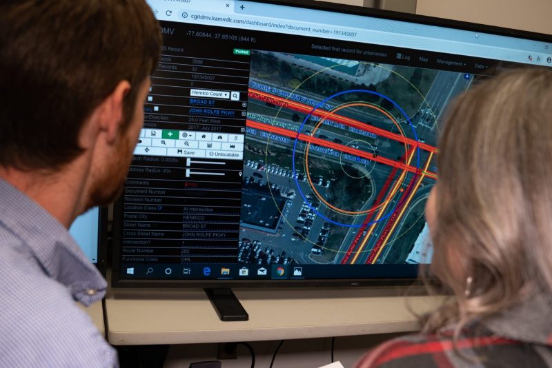
Each day and at all hours, about 15 people working for Virginia Tech’s Center for Geospatial Information Technology access approximately 2,500 accident reports and crash diagrams submitted each week from the Highway Safety Office, within the Virginia Department of Motor Vehicles. The information is reported by all Virginia police jurisdictions. The coders, many of whom are Virginia Tech students and alumni, use geospatial technology to pinpoint the location of each vehicle crash.
They send the final information to the DMV, which makes it available to each Virginia locality. Law enforcement agencies use this data to determine patterns and answer questions about vehicle crashes, such as why a large number may happen at a particular intersection.
And if they see ways to correct these issues, localities often use this information to apply for grants to fund changes.
“The more reports we have out there and the better information, the more grants local governments are receiving to fix their issues,” said Peter Sforza, director of the Center for Geospatial Information Technology and a research scientist in the College of Natural Resources and Environment. “The economic impact of this is probably enormous.”
This year, Sforza and his team at the center, in partnership with faculty in the Charles Edward Via Jr. Civil & Environmental Engineering Department, received the Governor’s Transportation Safety Award in the Innovation in Highway Safety category. This is the first time that the center has received an award in this category, which recognizes an individual or organization for developing and implementing unique and innovative approaches to improving highway safety.
See full story here.
