

Internet-based database of water pipes infrastructure
Researchers from CGIT worked with Dr. Sunil Sinha and graduate student Rahul Vemulapally from the Via Department of Civil and Environmental Engineering to create the prototype of a national internet-based geospatial database of underground water pipes. Funding was provided by the U. S. Environmental Protection Agency and the National Science Foundation.
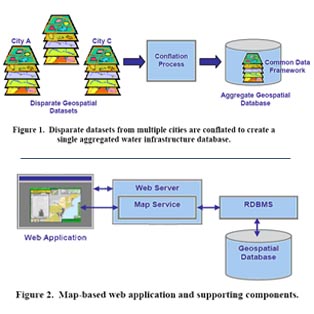
The Internet prototype application was created based on underground water and sewage pipe information supplied by three of the 17 cities that are partnering with Dr. Sunil Sinha and CGIT - Atlanta (Ga.), Pittsburgh (Pa.), and Seattle (Wa.) The geospatial database includes rich, interactive maps of the water pipe infrastructure, as well as data exploration tools and reports. Users are able to pan and zoom or easily identify attributes such as pipe diameters, size, or current condition.
See our Previous Projects
